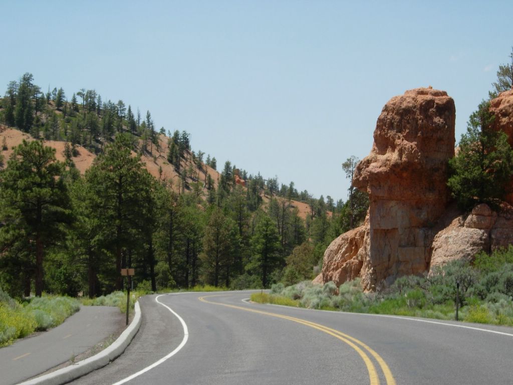
Winter and Spring of 2005 in the Colorado Rockies

Thursday, November 17, 2005

Europe Blog

The Europe blog is up. Check it out at http://whereisross.blogspot.com. It will be updated daily for the next two months.

Tuesday, July 05, 2005

The End


This completes Summit County Adventures and the great time that I had living in Colorado during the Winter and Spring of 2005.

Monday, July 04, 2005


On the way back to Oakland I drove over Tioga pass through Yosemite. After seeing Zion NP two days ago, Yosemite seemed less impressive. I didn't even stop as I was eager to get home and take a shower. The Central Valley without A/C was pretty brutal as well.


As I was eyeing my final run down Climax, I was joined by Glen Plake who had dressed for the occasion with red white and blue clothes, red white and blue skis and a red white and blue mohawk.


There was still plenty of snow left on the ground. This is at the top of Climax which was a lot of fun today.


For those of you who have skied at Mammoth before, I bet you didn't know this sign was so tall. I have a picture from a few years ago taken in February with my arm resting on top of the post. My guess is that this winter they had to dig it out to keep it from getting buried. Mammoth got a total of 607 inches (50ft) of snow this year! Incredible.


I camped just outside of Mammoth Lakes. This was my view in the morning when I woke up.

Sunday, July 03, 2005


Death Valley was the next stop on my trip. I drove through right around dusk and was treated to a nice colorful sunset. As you would expect it was hot. A thermometer I saw at about 9pm when it was already dark read 118�F. To make things worse, the air conditioner in my car ceased to function after I had been in the valley for about 10 minutes. Not a good thing. The drive through the valley was rough. For about two hours I was sitting there sweating my ass off praying that the rest of my car wouldn't decide to follow the same path as my A/C. Even in the Owens Valley it was hot. It wasn't until I I gained some elevation on 395 that it cooled off. You never realize how vital A/C is in a car until you don't have it.

Vegas Baby, Vegas!

I drove through Vegas after the Grand Canyon. Just to the East of Vegas (maybe 30 minutes on I-15) there is an Indian reservation where they sell fireworks. In California, you can generally do things on Indian reservations that are not legal in the rest of the state, like gamble. In Nevada you can gamble anywhere and buy safe and sane fireworks anywhere, so what do the Indian tribes do to offer a unique product? They sell really high powered fireworks. You can buy stuff like bottle rocks, black cats, M-80s, and the fireworks that shoot several hundred feet into the air and explode like professional fireworks. Being that it was the afternoon of July 3rd, the place was packed. Selection was pretty limited too, but the next time I make a road trip to Vegas, I will definitely make a detour to stock up.
In Vegas I stopped at the brand new Wynn casino. That is a pretty swanky place. I would say it rivals or betters the Bellagio. Not surprisingly I couldn't find any $5 blackjack tables on a Saturday afternoon.


I ate breakfest at the North Rim lodge. Talk about a restaurant with a view!


My car collected a bird while driving through the park. So sad :-(


Seeing the Grand Canyon after seeing Zion and Bryce canyons was a little underwhelming. It is so enormously huge that you really can't comprehend how big it is. There are no references for scale. In Zion you can walk right up next to the walls and understand how big it is. The Grand Canyon seems less intimate.


After Zion I headed into Arizona to see the Grand Canyon. I camped near the North Rim entrance to the park. I headed to the viewpoints first thing in the morning. The North Rim of the Grand Canyon is very heavily forrested. You don't get out of the forest until you get right to the rim of the canyon. Once you get there it is quite a difference.

Saturday, July 02, 2005


"The Narrows" is a hike you can take up the canyon at its most narrow point. It involves a considerable amount of wading in addition to hiking. Unfortunately the hike was closed in early July due to high river levels. I was so disappointed. I brought my swimsuit and everything.


Looking up the canyon towards "the narrows"


Zion canyon is incredible as well. It is a very narrow canyon with walls that tower more than 3000ft above the river. This rock face is apparently Zion's equivalent of El Capitan.


Near the entrance to Zion canyon. The walls of the canyon are spectacular shear rock faces.


***September Updates begin***
I entered Zion through the East entrance which has a narrow little road which twists its way down towards the valley. The scenery was incredible. It reminded me a lot of Yosemite's high country with Sandstone instead of Granite. There were massive rock formations and domes everywhere. The rocks had huge amounts of beautiful colors as well.


Some other cool formations along the road. All of southern Utah is basically like this. There are amazing sights everywhere


Checkerboard Mesa in Zion National Park.


On the road from Bryce to Zion. I saw lots of rock formations that looked like faces such as this one. I guess it is a common erosion pattern.


Hoodoos in Bryce Amphitheater. The view was incredible and the photos don't even do it justice.


Natural Bridge in Bryce Canyon NP


A Hoodoo (vertical rock formation) in Bryce Canyon National Park. I thought this looked like a fist giving a thumbs up.


Grand Staircase - Escalante National Monument. The Grand Staircase is the long mesa in the distance.


Dixie National Forest between Capitol Reef NP and The Grand Staircase Escalante National Monument. Quite a contrast to the surrounding desert areas.


Some of the Capitol Dome like rock formations that the park is named after


Hiking down Capitol Gorge in Capitol Reef NP

Friday, July 01, 2005


Navajo Dome in Capitol Reef National Park. I arrived at the park at sunset and camped at the campground in the park. It was $10 to sleep under the stars next to my car. I paid most of the fee in change since I didn't have the right bills. They probably weren't too happy to get about 50 pennies.


On the road to Capitol Reef National Park


Mesa Arch in Canyonlands NP


The Green River


Canyonlands National Park. I visited the Island in the sky section which is a big mesa near the confluence of the Colorado and the Green Rivers.


Amazing Rock formations near the Colorado River


Biking the slickrock trail


The Slickrock bike trail in Moab


Park Avenue


Turret Arch


Tunnel Arch


Skyline Arch


Cool Tree


Landscape Arch


Dawn at Arches National Park

Thursday, June 30, 2005

I hate moving

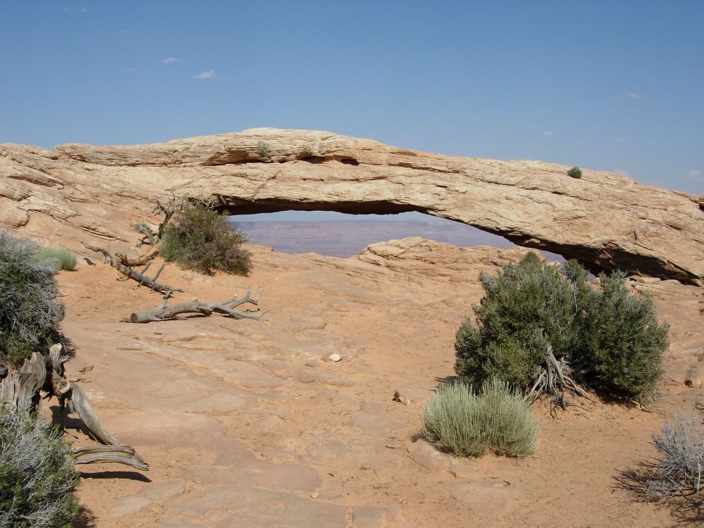
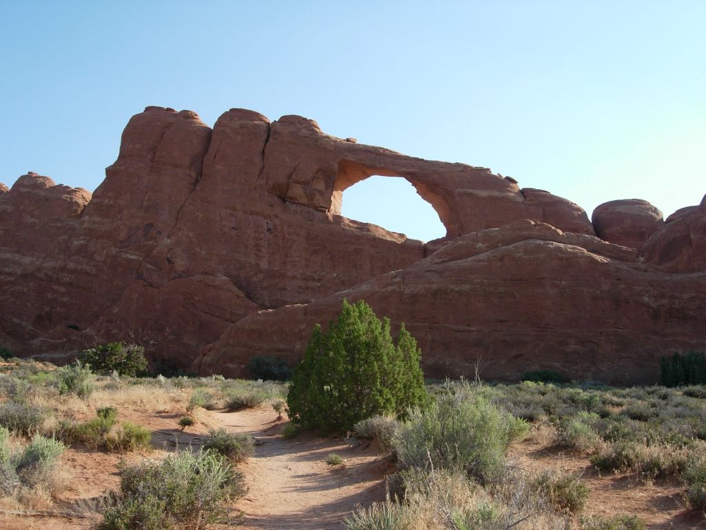
It seems like my life is a never ending series of moving from one place to another. Since June of 2004 I have moved 8 times. That is not a typo (most of those were related to my never ending thesis ordeal). Since 1999, the longest I have stayed in one place was 12 months. In the same period I have moved a total of 16 moves in 6 years. I'm getting ready to get settled somewhere for a while soon. I spent the last day and a half packing, cleaning and cutting ties to Breckenridge. It was exhausting. The last few days have been non-stop with little time to sleep or rest. I've accumulated a lot of new things since coming to Breck which made it a lot harder to pack. I finally finished up around 8pm tonight and hit the road heading home. I spent the night in Fruita which is near the Utah border. Tomorrow I will leave Colorado for good. I won't get much sleep tonight either because I'm going to get up before dawn to go to Arches National Park.

Wednesday, June 29, 2005

Trail Ridge Road


The road which crosses the park is called Trail Ridge Road and is the highest continuous paved road in North America. It traverses a high ridge with spectacular views to both sides. This is looking SE back towards Long's Peak. Most of the park looks a lot like other parts of the Rockies. The high road is pretty unique though. I would imagine that there is some very good wilderness camping available in the park as I doubt many people venture beyond the road and the Long's Peak area.
I drove through Granby, Winter Park and over Berthod Pass to get back to I-70. It was a long day and I was pretty exhausted. Just the perfect state to be in to pack up all of my stuff so I could move tomorrow.

Rocky Mountain National Park


I took the scenic route home from Long's Peak by driving through Rocky Mountain National Park (RMNP). I just drove straight through and didn't really venture too far beyond my car. The views were very nice.

Failure


This is a view of Longs Peak's East Wall from the Highway. The clouds had almost lifted by the time I took this photo about 3 hours after I turned around at the Boulderfield. It wasn't worth the risk to wait. It looked like the summit cloud would be replaced by thunderstorms shortly as well. This was my first failed attempt at a fourteener. Ironically (or maybe logically) this would have been my 13th fourteener if you count the ones I have climbed in California. It does give me a reason to come back to Colorado though. I will conquer Long's Peak and Hahn's Peak someday.

Decisions


The view from the Boulderfield was not encouraging. Normally at 7am in Colorado you would have crystal clear skies. I picked the wrong day to do this hike. This point is about 1.5 mile and 1500 vertical feet from the summit. Probably about an hour in good weather. Somewhere in that cloud is the keyhole which marks the beginning of the Class 3 scramble up to the summit. The clouds were not showing any signs of lifting. I sat around at the Boulderfield and talked with some of the other groups about whether to continue on. We all decided to turn around. I was hesitant to proceed on a technical snow climb in poor visibility with high winds. I didn't want to wait around to see if the clouds would lift as it could be hours of waiting for an uncertain outcome. I started hiking back down the trail passing a sea of people coming up. I probably passed 50-75 people and a few llamas on the way down. It was weird as I neared the trailhead to have people saying good morning to me as I was finishing a 12 mile hike at 11am.

Sunrise on the Longs Peak Trail


I reached treeline in about an hour. By this point it was getting bright enough that I no longer needed a headlamp. Above the trees the wind picked up substantially. There was a pretty strong steady wind with some powerful gusts. The summit of Long's Peak was shrouded in clouds. As I passed the Chasm Lake junction it was not possible to see much of the mountain at all. I had passed several groups of hikers on the trail at this point. At Granite Pass the wind became intense. Some gusts were strong enough to knock you off balance. I pushed up the trail toward the Boulderfield which is where the climb begins to get difficult. The trail appeared to be leading into a big cloud which was not good.

Earliest Start Ever

It was a little rough sleeping in the car. Around midnight it started raining. Later the wind picked up tremendously. The gusts were rocking my car quite a bit. Normally in Breckenridge at night the weather is pretty still. I was nervous that this weather was indicative of bad things to come the next day. I woke up bleary eyed a bit after 3am. I got my gear together, got dressed, made some sandwiches and hit the trail before 4am. The wind was still howling. When I signed the book at the trailhead I saw there were already 3 parties ahead of me on the trail. I switched on my headlamp and headed into the darkness. Of course I forgot my sunglasses again but realized it only 2-3 minutes into the hike.

Tuesday, June 28, 2005

Travels

After biking I packed up my day pack and headed up towards Rocky Mountain National Park (RMNP) to climb Long's Peak tomorrow. I drove CO-119 through Central City which I was surprised to find is full of casinos all tucked into a narrow valley. I guess this is where Denver people go to gamble. I continued on 119 towards Boulder. The drive through Boulder Canyon was pretty cool. I can see why this area is such a rock climbing mecca. There were an endless assortment of walls and other great climbing rock. I stopped in Boulder for dinner. I'd never been to Boulder before and wanted to check it out. The city center was nice with lots of shops and restaurants. It felt a little like Berkeley, but the city center was a bit nicer. The homeless people seemed more like the "I flunked out of school and wanted to stay here" homeless people than the "I'm crazy" homeless people you find on Telegraph Avenue. Some of the residential neighborhoods I drove through were nice and cozy as well. After Boulder I headed for RMNP arriving at the trailhead around 11pm. Despite signs saying "No Camping in Parking Lot - Strictly Enforced" I slept in my car. My plan was to get up around 3am to begin hiking.

Freeride


I rented a "freeride" bike over at Copper Mountain (for some odd reason Keystone doesn't have long travel full suspension bikes for rent) for the day. It was Giant AC with 6in of travel front and rear. It was the first time I had ever really ridden a full suspension bike on real trails. I think this is about a $3000 bike. It was very nice. The ride was super plush, especially the rear suspension. You could sit down for most of the downhill and not really feel much of the roughness at all. The front fork was pretty stiff, but it soaked up big hits very well. The bike also had hydraulic disc brakes front and rear. These were very nice. They had a very progressive feel and incredible stopping power. On a lot of the trails you are on the brakes non-stop. I was surprised that even these brakes began to overheat at times. I can't even imagine how the brakes on my bike would have howled on the descents. The bike definitely made it possible for me to ride a lot further today than I would have been able to on my hardtail. I don't think I could ever justify spending $3000 on a bike, but a rental for $35 a day plus a $28 lift ticket is not bad to get a taste.

Cruising


These two photos are self portaits taken with a tripod and the 10 second timer on my camera. I bet you never would've guessed. It was pretty hard to do.

Downhilling at Keystone


Keystone runs a lift during the summer to carry bikes to the top of the mountain. In about 10 minutes you gain 2700 vertical feet and the trails to the base are almost all downhill. Today was my first experience with lift serviced downhill mountain biking. It was a lot of fun but utterly exhausting. I did 5 laps on the chair and ended up riding over 30 miles down all sorts of trails. There are good variety of trails down the mountain (trail map here). Trails are marked with familiar green, blue, black and double black ratings. I started out on greens with names like Girl Scouts and Easy Street. These single track trails were technically easy, but still physically demanding. It was a long way down no matter which way you went. It generally took me 45 minutes to an hour to get down. (It takes 5-10 minutes to ski the same distance in the winter). The trails wind their way down the mountains crossing ski runs and traveling through the forest. Trails like Let it Ride seemed to go on forever. If you took the green trails all the way down it was about 8 miles top to bottom.
I eventually worked my way up to some blues which were not much more difficult than the greens. Maybe a little steeper in places. Then I decided to try the black diamond trail "Cowboy Up." It was one of the most technical trails I have ever ridden. There were some really steep sections and a few substantial log drops. I wasn't too comfortable with an unfamiliar bike with no clipless pedals. I was heading down through a nasty rock garden when I got to a section which looked too tough to ride. I saw some people coming up behind me so I scooted off the trail to watch them come down. The first guy who looked like he knew what he was doing and had the right bike and the gear to be riding the trail bailed on the section that I stopped for. He went over the bars and landed pretty hard. I walked that section after seeing that. I decided the blacks were a little out of my league today. I can't even imagine what the double blacks were like.
At the end of the day I was exhausted. Riding 30+ miles on rough trails does a number on your body, even on a plush full suspension bike. My arms were especially tired. Overall it was a great day. Not having to ride uphill is kind of weird, but it really maximizes excitement. Riding uphill at Keystone would be brutal because of the elevation gain.

Monday, June 27, 2005

Has anyone seen my trekking poles?

I realized today that I haven't seen my trekking poles (actually my Dad's trekking poles) since my hike of Red Mountain last Tuesday. When I climbed peak 10 on Friday I figured I left them at home when they weren't in the back of my car. Today I looked for them in my condo and couldn't find them. My best guess as to where they went is that I left them leaning on the side of my car when I left Boreas Pass last Tuesday. I must have just driven away and left them there. I drove up to the pass today in the hope that they would still be there, but they were gone. Not surprising almost a week later. I guess I owe my Dad a new set of poles. The ones that I lost sucked anyway, so I'll have to get some nicer ones.

Sunday, June 26, 2005

Going Back to Cali

This is my final week in Colorado. I am driving home on Thursday. If anyone wants me to bring back any souvenirs please let me know in the next few days.

Saturday, June 25, 2005


Our group at the end of the day